I. Background. Dartmouth acquired most of the properties within two substantial blocks of downtown Hanover during the late 1990s. In the more distant block, called South Block, the Real Estate Office demolished most of the buildings and created a fairly intricate series of mixed-use replacements following a master plan by Truex Cullins. A below-grade parking deck fills the center of the block. The result is impressive: in the image below, the two commercial buildings north of the square white roof anchor the project, and the new buildings continue eastward along the street at the top of the image (South Street).
II. Phase Two. The projected second phase of the project will address the Sargent Block, along Lebanon Street. Located diagonally opposite South Block, this block is much closer to the center of campus. It includes the Lodge, an old motel converted to a dormitory decades ago.
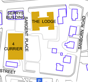
This part of the project has been slow to get off the ground. C.J. Hughes reported in a 2010 Alumni Magazine article on the Lodge that the Sargent Block redevelopment has been put off until at least 2015. Dartmouth has built only one building in the block, 4 Currier Place, which architects Truex Cullins describe as “the first phase of the master plan for the Sargent Block redevelopment.” An old planning document (pdf) suggests that the redevelopment would replace 22 dwelling units on the site (rental units, not dormitory beds) and add an additional 113 units. Dartmouth has not released any information about a potential master plan for the block.
III. The Master Plan. A campus tour map posted on the Admissions website as late as August of 2010 included the then-current master plan for the Sargent Block:
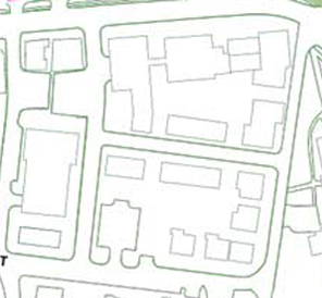
Here is the master plan layered atop the existing conditions:
The master plan has probably changed since it was (somewhat inadvertently) published, but at the time, it seems to have been accurate. The map shows a number of interesting moves by Dartmouth.
The college is buying into the proposal in the town’s 2000 master plan that this block be divided by a new east-west street. In addition, the existing but somewhat vestigial Sargent Place is continued through the block. Both of these changes will improve circulation and make the closing of the north end of Sanborn Road an easier proposition.
The map indicates:
- The removal of three or four historic houses;
- The construction or relocation of two houses and one large addition;
- The construction of at least two large commercial buildings and six smaller ones; and
- The construction (apparently) of an underground parking garage.
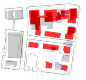
The plan appears to retain the C&A Pizza building. The old frame house and its commercial addition add a lot of character to the street; the website says that C&A has been going since 1976, and that could be the date of the addition.
East of Sargent Place, the Lodge is to be demolished, of course. This will move the effective southern boundary of the campus to the other side of Lebanon Street and make Topliff the school’s southernmost dormitory — a big step. Also to be removed, at least according to the master plan, are the Victorian frame house of the Jewel of India and the solid brick house containing Kleen.
The Jewel of India really must be removed from its crucial corner site. It also really should be preserved, and its frame construction would make it relatively easy to relocate to a site in the southern part of the block. The appealing Kleen building is so substantial that it would seem a waste not to incorporate it into the redevelopment. But it is not a rarity in Hanover, so it might be hard to argue for.
Around the corner onto Sanborn Road, the plan shows the removal of two frame houses. Below the new cross-street, the two existing houses are preserved, one with an addition to bring it out to the corner — nice. This southeastern corner of the block is depicted as preserving the residential character of the immediate area, however small that area is.
IV. Conclusion.The plan only hints at the buildings that might someday form a new gateway to Dartmouth. But it is a positive sign.
———
[Update 08.12.2012:
Something about the plan rang a bell: This presentation (pdf), linked here during 2008, has a more detailed version of the plan and even a few perspective renderings. The first rendering shows the intersection of Lebanon and Sargent Place looking south. That’s the Serry’s Building on the right and the Lodge replacement on the left. Compare this view:
Walking down Sargent Place to the new corner and turning left would reveal the second view included in the presentation. The third image is hard to place but might be a view to the south along Sanborn Road or west along South Street.
What about the plan as a whole? It seems quite appealing. It is hard to believe that a ratty parking lot could be turned into this neighborhood. Replacing a dormitory (the Lodge) with rental housing and commercial buildings amounts to an unusual retreat for the college, a constriction of the borders of the campus. At the same time, the plan is not meant to rule the outcome: the flat roofs and streaky-bacon brickwork will not emerge precisely as they are depicted. For an example, compare the semi-Modernist reality of 4 Currier with the gabled prediction of the early views.]
—–
[Update 05.03.2014: Broken link to 4 Currier page replaced.]
[Update 11.17.2012: Broken link to old planning document fixed.]