-
The cemetery is an obstacle to cross-campus foot traffic and contributes to the perception that the business and engineering schools, not to mention the River Cluster dormitories, are distant and isolated.
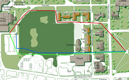
To get from the Green to the River Cluster, one has to walk north to Tuck Mall and then west, following the red line on the map below. West Wheelock Street looks a little shorter on a map, but most people do not walk that way because the elevation changes so much. The traffic along West Wheelock also makes the walk not particularly pleasant.
-
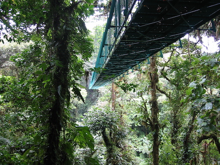
During the late 1920s, college architect Jens Larson proposed to solve this problem by building a bridge for pedestrians right over the cemetery (indicated on his 1928 master plan). The blue line above shows the approximate route. The cemetery contains several ravines, so this bridge would have flown through the treetops. It might have been like the Sky Walk in Monteverde Preserve in Costa Rica, a bridge system that has been in magazine ads lately.
Larson’s bridge was never built. It would have been an expensive way to provide mere convenience and seems unlikely to have been received well by the cemetery authorities.
-
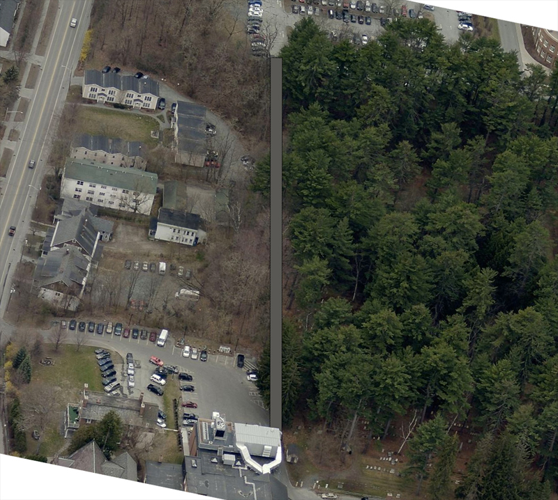
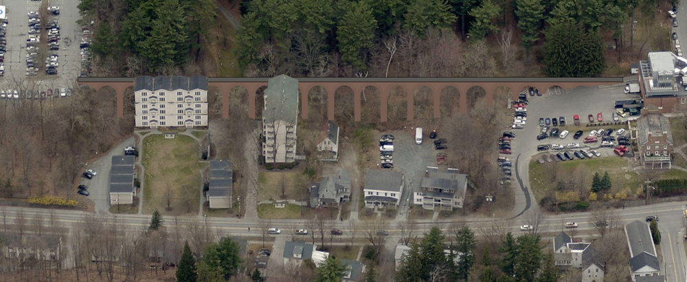
But what about skirting the cemetery’s southern boundary with a bridge or causeway built on private land acquired by the college? The green line on the map above shows this route.

In the image above, based on a Bing aerial, the roofs of Thayer Dining Hall/53 Commons are visible in the foreground. A Bing view of the site from the west shows how the viaduct would create a circulation network; see also a view of the site from the south.
A Street View partway up Thayer Drive, the road that leads through the trees from Wheelock Street to Thayer School, shows just some of the elevation change that one would avoid by using the viaduct. See also a view from the east.
-
A viaduct here could take the form of a Larson-style brick arcade, like the one that connects Streeter to each of its neighbors in the Gold Coast, or the front facade of Memorial Field’s grandstand. This would be expensive. A stone arcade would be even more expensive. The viaduct could be a timber-framed College-Grant style suspension bridge, interesting but perhaps ephemeral. An enclosed airport terminal bridge like at Thayer (Street View) would be expensive and unnecessary. The most interesting form might be that of a very “engineered” steel bridge that recalls the Ski Jump tower. The cheapest and sturdiest form might be a basic utilitarian concrete bridge like that of the rear of the Fairchild Center (Street View) or the side of the Boss Tennis Center.
-
Those apartments along Wheelock Street are not apparently owned by the college, but they should be, and one guesses that eventually they will be.
This area probably should be left in apartments no matter who owns the land. Dartmouth could do a South Block project here, selectively improving or replacing buildings and potentially integrating the buildings with the viaduct. The spaces under the walkway could be inhabited or at least occupied, as in Viaduc des Arts in Paris.
-
By making the buildings rather tall and connecting their upper levels to the bridge, the college could even produce something like the 19-arch South Bridge in Edinburgh of 1788 (Wikipedia, historic-uk.com). A person standing on top of that high-level street in Edinburgh faces what appears to be the ground level of a modest building; in fact, he is at the fourth or fifth floor, with the lowest level of the building resting on the bottom of a valley (Bing aerial).
In Hanover, some of the buildings on the Wheelock Street side of the bridge would be five or six stories high — towers, really:
—–
[Update 12.23.2013: Larson’s 1928 plan from the Previous Master Plans portion of the school’s Master Plan website shows the proposed cemetery bridge as a masonry structure. The suggestion that it was to be a suspension bridge has been removed.]
[Update 11.03.2013: The town is having Plan NH run a West Wheelock Street design charrette next weekend:
The Hanover Affordable Housing Commission and Hanover Planning Board recognize underutilized residential land area close to the downtown, a prominent gateway to our Main Street commercial district and the Dartmouth College campus, challenging topography, and the need to accommodate high traffic volumes with pedestrian safety.
(Via the Planner’s Blog.)]