The firm of RSG writes that, in connection with the BBB master plan, it:
conducted a comprehensive evaluation of traffic circulation around the campus green, which included the development of a detailed microsimulation model to evaluate the merits of various alternatives.
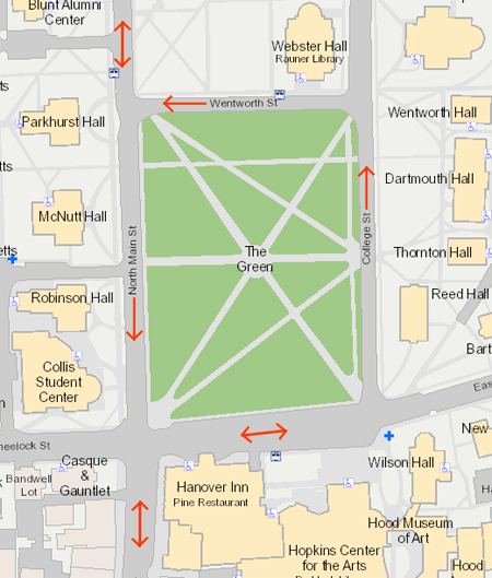
It is a good bet that one of the alternatives for the Green is the return of two-way traffic. Here is the current traffic pattern:
It is not clear when the streets around three sides of the Green were made one-way streets. Much of the one-waying done in the Sixties and Seventies in the interest of moving traffic through American cities is now seen as undesirable for a number of reasons. The Yale Master Plan (pdf) has several observations on pages 45 and 119:
Bicyclists tend to go the wrong way on one-way streets if they view it as the shortest path to their destination. This fact suggests the benefit of reconfiguring those streets to make cycling and walking easier.
One-way streets can be particularly hostile to those visiting Downtown, and motorists often see destinations but must recirculate through the system to reach them…. Motorists must travel further and turn more in one-way street systems than along two-way streets, and crossings are also particularly difficult for pedestrians. We recommend encouraging the City to expand its recent conversion of one-way streets to two-way traffic…. New Haven would certainly not be alone if it followed this initiative. Because of the direct impact of transportation on the accessibility and viability of urban centers, many cities are examining traffic patterns and the balance among transportation modes. To return downtown streets to a human scale and promote a more pedestrian and retail-friendly environment, recent initiatives in many places have concentrated on slowing traffic, and more and more cities have converted (or are considering converting) the one-way streets to two-way.
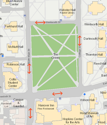
Here is a look at the Green with two-way traffic:
The Yale plan states on page 119:
Those traffic engineers and planners who support converting the one-way streets to two-way use readily admit that the change might selectively increase traffic congestion. However, rather than concentrating on their lost capacity to move vehicles, these professionals focus on the slower, calmer traffic and how that improves the livability and potential for growth of urban environments, business districts and neighborhoods.
Another alternative at Dartmouth might adopt another extreme, a pattern that attempts to eliminate traffic from as much of the Green as possible:
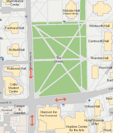
Expanding the Green in this way could make for some very pleasant spaces, particularly if the grass were carried up to SAE. Care would have to be taken to preserve some of the proportions of the streets in the paths that replaced them, an effect not shown here. Although closing College and Wentworth Streets would increase traffic on North Main and Maynard, the increase probably would not be great. Outside of term time, the Green would seem more like a dead zone (or a park, depending on your perspective) than it does now.
The list of alternatives would not be complete without a traffic circle:
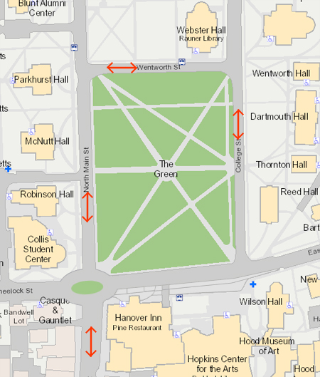
The college planners probably are not thinking of this alternative, since the redesign of the town’s main intersection seems to be more of a task for the municipal authorities. This option also removes the space-hogging diagonal parking and the turn lane from the south end of the Green.
—–
[Update 02.08.2014: RSG concludes (pdf) that “we do not feel that any of the two-way Green circulation options warrant additional investigation.” Very interesting. The report does, however, propose to narrow East Wheelock in front of the Hop in much the same way the image above does.]